Please select your home edition
Edition
PredictWind - Wave Routing 728x90 TOP


New upgrades to Predictwind's ocean and tidal current maps

by Predictwind 21 Jul 21:55 NZST 21 July 2024
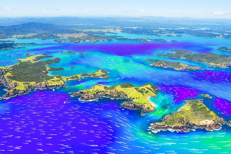
Predictwind current/tide forecast - New feature - July 2024 © Predictwind

In the pursuit of continued improvement Predictwind has announced new upgrades to our ocean and tidal current maps.

These enhancements are designed to provide users with even more accurate and detailed tidal and current information.

The alignment between PredictWind and top level sports is part of the company foundation. For the Paris 2024 Olympics the harbour off the City of Marseille will host the Sailing events. PredictWind has developed an Ultra high-resolution current model for Marseille. This is a completely unique dataset that will help the competing Olympians better understand the complex movements of the water they are sailing on.

Each day can be different as the currents are driven by wind and the density difference in the water column. The wind influence can bring upwelling along the coast (cold water from the deeper ocean comes to the surface) and increase the water temperature difference. It can also bring fresher water from the river Rhone into Rade de Marseille. Another factor is the Northern current (current that flows counterclockwise along the coast of France) being pushed into the bay.

The collaboration with the pinnacle of sport has a great flow down effect for all PredictWind users. What we learn is pushed across all areas of our products. Along with the unmatched tidal coverage that PredictCurrent offers, we have added more new ultra high resolution regions. So far this year, we have added the following 100m resolution locations:

  • Bay of Fundy, Canada
  • Elliot Bay, WA, USA
  • Oak Harbor WA, USA
  • Hood River OR, USA
  • San Francisco CA, USA
  • Marseille, France
  • Derwent, Australia
  • Lyttleton, New Zealand
  • Bay of Islands, New Zealand?

These additions enhance our coverage and provide more localized and accurate current data for these regions.

For those venturing further offshore we have two changes.

  • The first is improved tidal and ocean current merging. The convergence zone between the high resolution tidal currents and the low resolution ocean currents now has more accurate interpolation.
  • The second change is comparing the Ocean Current models. You can now view Ocean Current from three different sources: Mercator, Hycom and RTFOS. This feature displays the raw (unmerged) Ocean Current data so you can compare the differences between each of the three models.

Additional Images:

Related Articles

Predictwind is official partner of Vendee Globe
PredictWind will bring fans into the Vendée Globe action with a world-first Race Weather Centre Global leader in marine weather forecasting, PredictWind, has announced its official partnership with IMOCA - one of the fastest and most exciting offshore yacht racing classes - to become the exclusive Weather Data Supplier for the Vendée Globe 2024. Posted on 22 Oct
Official Weather Supplier for the Vendèe Globe
The world's most prestigious solo round-the-world race We're delighted to announce our partnership with IMOCA, one of the fastest and most exciting offshore yacht racing classes, as the Official Weather Supplier for the Vendée Globe. Posted on 20 Oct
PredictWind's new innovative Climate Data feature
Historical weather pattern data empowers users to better prepare for adventure Global leader in marine weather forecasting, PredictWind, has unveiled a groundbreaking Climate Data feature Posted on 16 Oct
PredictWind powers Cup teams and fans alike
PredictWind has reinforced its status in providing accurate and cutting-edge weather forecasting As the Official Weather Data Supplier for the 37th America's Cup, PredictWind has reinforced its status as a leading authority in accurate and cutting-edge weather forecasting for elite-level sailors. Posted on 28 Aug
PredictWind unveils the new PredictCurrent app
The world's most advanced tidal current app This specialized app grants access to incredibly detailed current data, offering an optimized interface for enhanced usability with a quick-view dashboard showing wind, current, waves and tide height all in one place. Posted on 4 May
The Importance of Weather Forecasting
Understanding forecast weather conditions can be crucial to your survival PredictWind is a world-leading weather forecasting tool for boaters. Weather conditions such as storms, high winds, swells and currents can cause havoc for those on the water. Understanding forecast weather conditions can be crucial to your survival. Posted on 1 Apr
Safe routing through the wind, waves, and current
Weather Routing does so much more than get you from A to B In seconds, know exactly what conditions are ahead, how comfortable the route will be, and how to safely and efficiently avoid bad weather, rough seas and shallow water with the world's most advanced routing algorithm. Posted on 19 Mar
Predictwind announce Over the Horizon AIS
Predictwind have released an all new Over the Horizon AIS (OHA) feature on the DataHub Predictwind, the world leading weather information, forecasting and routing service have released an all new Over the Horizon AIS (OHA) feature on the DataHub. Users can view AIS data out to 300nm, directly on your chartplotter and nav apps. Posted on 19 Feb
PredictCurrent: High-res tidal currents model
This groundbreaking solution empowers users to navigate local waters around the globe PredictWind, the leader in maritime weather technology, has announced the launch of PredictCurrent, the world's most comprehensive, high-resolution tidal currents model. Posted on 5 Dec 2023
PredictWind - GPS 728x90 BOTTOMPredictWind - GO! exec 728x90 BOTTOMPredictWind - Offshore App 728x90 BOTTOM